Starting from the A61 between Sheffield and Baslow, this Wellington’s Monument walk passes two monuments from the early 19th century at Baslow Edge and Birchen Edge and offers wide views over the Chatsworth Estate and the Derwent Valley
Wellington’s Monument Walk Overview
Distance: 4.7 Miles (7km)
Total Ascent: 868ft / 265m
Time: 2 hr 20min
Map: Ordnance Survey OL1 (The Peak District – Dark Peak Area)
Get this route on the OS maps website & app
The time is loosely based on Naismith’s Rule and will vary depending on the walker.
Getting There
By Car:
Roadside Parking on Clodhall Lane, near the crossroads with the A621 Sheffield to Baslow road. Turn left at the crossroads if travelling south from Sheffield. Close to Bar Brook Bridge (DE45 1PQ)
Public Transport:
Bus Service 218 Sheffield – Chatsworth – Bakewell stops at the Bar Brook Bridge bus stop next to the crossroads at the beginning of the walk
Walk to Wellington’s Monument
From the parking spot on Clodhall Road, walk west to cross over the main A621 and follow the minor road over a bridge and uphill. Upon reaching a gate on your left, go through the gate signed as a Restricted Byway and head along the clear track with a stone wall on your right.
As the stone wall ends continue along the track in the same direction, now with heather to your right and the woods of Jack Flat to your left until you reach Wellington’s Monument. The monument is a stone cross erected in 1815 by a Dr Wrench to commemorate the Duke of Wellington’s victory at Waterloo.

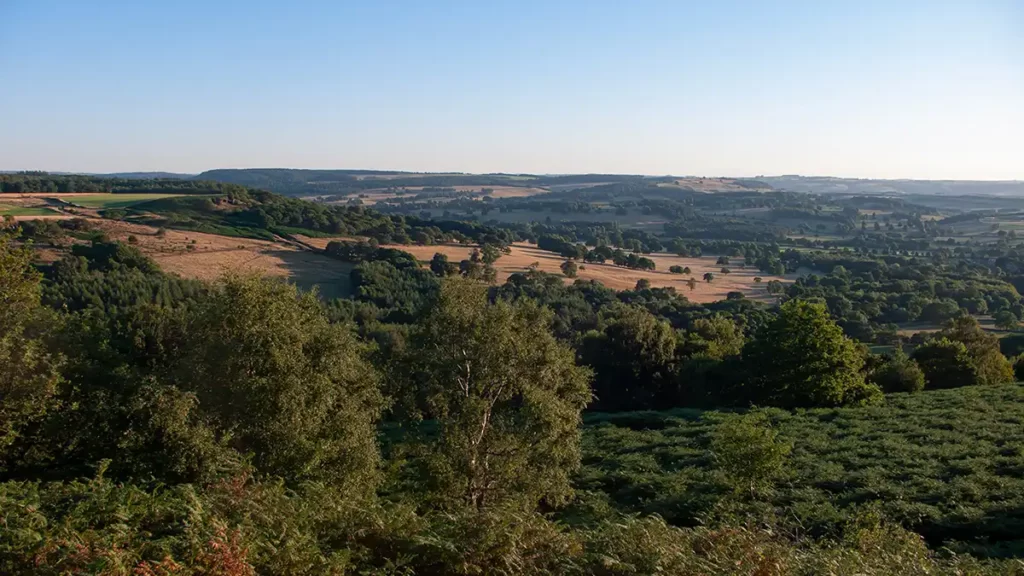
After pausing at Wellington’s Monument walk onwards. Just beyond the monument is a viewpoint with a bench, looking through trees over the Chatsworth estate, with Chatsworth House visible behind trees just left of the River Derwent.
Beyond the viewpoint, the path bears slightly right and then reaches a path junction. Turn left towards another bench with wider views of Chatsworth and the Derwent Valley ahead-right, and Gardom’s Edge ahead-left.

Continue downhill on the track which then bears left as it meets a stone wall. Follow the track left as it heads down towards a wooden gate, with Baslow Edge heading off to your right.
Jack Flat to the Robin Hood Inn
Before you reach the gate, pass a footpath marker post on your left and turn left here to join the path which heads almost back the way you came but at a lower level, beside a stone wall and fence to the right. The path is rough in places but easy to follow as it follows the line of the fence. After the fence heads off downhill to the right, the path continues straight ahead (east-north-east) through the woods at Jack Flat. As you descend after leaving the fence, if you look to your left up through the woods, you can see Wellington’s Monument once again.
The path drops to an old, moss-covered stone wall and then, at the wall corner, turns right, roughly following the wall. Follow the path downhill with the wall to your right through the wood. After a while, reach a gate and continue downhill between a fence and wall. Cross a bridge and emerge beside the A621 via a stile beside a gate
A621 to Gardom’s Edge
Walk across the main road and head over a stile opposite, up the public footpath left of a house. Climb a wooden stile and head up the obvious footpath with a fence to your right. The path heads through silver birch trees as it steadily climbs.
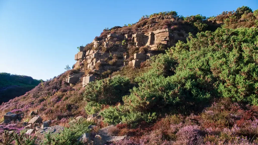
As you reach a stone wall, go over the gap in the wall and keep straight ahead (Do not cross the broken wall on your immediate right). Stay heading south by southeast with the stone wall to your right. The rocky path heads through bracken as it climbs. Views over Baslow and Chatsworth soon come into view on your right.
The path widens and bears slightly left as it heads uphill. Remain on this path passing an old gate post at a gap in a stone wall. Cimb to a large, flattish rock at a viewpoint with a wide 180 degree vista at the far end of Gardom’s Edge
Gardom’s Edge to the Robin Hood Inn
After the viewpoint, head southeast through the gate/stile and along the path choosing any option except the leftmost.
As you walk past the rocks to your left, if you look ahead left you can see Nelson’s Monument standing atop Birchen Edge, looking almost like an enormous dolly-peg.
The path soon widens and heads generally southeast, gently descending until it reaches the main A619 road via a gate and stile. Turn left along the footpath beside the road up to the road junction beside the Robin Hood Inn.
Robin Hood Inn to Nelson’s Monument
Beside the Robin Hood Inn turn left up the B6050 road. Pass the public house and the car park, continuing along the road past the Robin Hood B&B. After the B&B, beside a driveway, take the public footpath that heads up alongside and above the road.
Pass through a gate and then turn left, climbing the steps and ascending a path with a fence and stone wall to your left. On reaching a path junction, turn right to head steeply up to Birchen Edge – a short but strenuous climb which may involve using hands near the top of the ascent.
At the top of the steepest section, continue ahead on the path, ascending much more gently to the top of Birchen Edge, where the path turns 90 degrees left.
Continue following the path along the top of Birchen Edge until you reach Nelson’s Monument, a 10-feet high gritstone column. The column was erected in 1910 in honour of Admiral Nelson after his victory and death at Trafalgar.

Descent from Birchen Edge
Once you have passed Nelson’s Monument continue along the path to the trig point. Shortly after the trig point, the path drops slightly, still atop Birchen Edge. When you pass a rock outcrop on your left, the path forks with a fainter path heading left steeply downhill. Take this left path. Descend with care as, especially in the summer months, rocks and ruts may be obscured by bracken.
After a short steep section of descent, the path levels out a little. Continue heading northwest on the path through the bracken to meet up with a clear path running left to right.
Turn right and follow this path which heads north across moorland and gently down to Clodhall Lane via a gate. Turn right back to the car, or left back to the bus stop.