A walk to the historic Magpie Mine from Monyash at the head of the Lathkill Dale Path
Beginning from the village of Monyash at the head of Lathkill Dale, this round walk visits Magpie Mine, once the largest lead mine in the Peak District, with a well-preserved chimney and engine house. The remains of Magpie Mine serve as as reminder of the early industrial past of the now pastoral area.
The route then heads across pastures and farmland, before dropping down to the River Lathkill and following the scenic Lathkill Dale path back to Monyash
Distance: 7.94 Miles (12.7km)
Total Ascent: 775ft / 236m
Time: 3hr 35mins
Monyash to Sheldon
From the small green beside the Bulls Head public house, head North along Chapel Lane (Signposted Flagg & Sheldon) and pass the chapel on your right. Continue to a road junction and turn Right onto Horse Lane, then almost immediately take the Public Footpath on the left, over a stone stile and walk steadily uphill with the woods to your right. Continue along this path through four fields, crossing the stone stiles until you reach Nursery Hall Farm.
After passing the farm on your right, the path turns half-right. Follow this path across the field, passing a small plantation on your left, to arrive at a straight, walled track. Follow this obvious track until you reach the road.
Cross the road and take Wheal Lane, a walled vehicle track until a gate on the right . Turn right, heading roughly East through the gate and follow the path uphill over fields. Keep following the path over numerous stiles and a gate, passing through several small fields to reach Johnson Lane, at the edge of Sheldon village.
Turn left onto the lane and follow the road into Sheldon
Sheldon to Magpie Mine
Whilst a shorter route to Magpie Mine exists by turning right as soon as you reach Sheldon, our route takes in this small village which offers refreshment at the Cock & Pullett inn, if you so desire.
Walk through Main Street, descending gradually through the village, passing the inn on your right and continue to the end of the village. After passing The Byre on your right, turn right through a hand gate beside a full gate and follow this path, soon following a dry stone wall on your right.
As you reach the corner of the stone wall on your right, bear slightly left across the next field, cross a stile then walk along the left edge of the next field until you reach a path junction. Pass through the gate on your left, then take the path which leads diagonally across the field and continue ahead to reach the remains of Magpie Mine
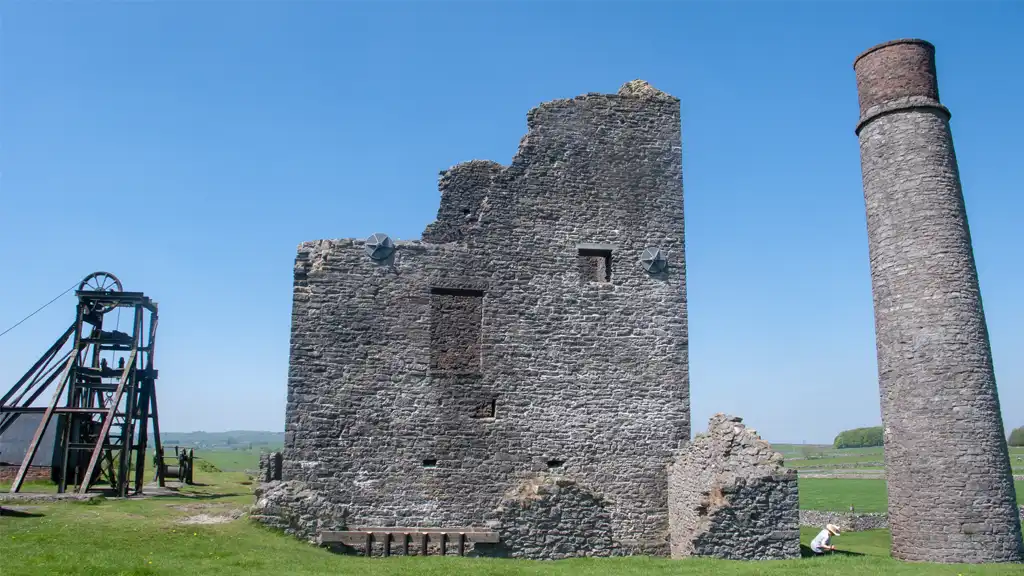
Exploring the site of the mine, the chimney and the engine house, you will see plenty of information posts detailing the history of the mine. In particular you can read about the tragic rivalry between Magpie Mine and neighbouring Maypitt Mine. This rivalry culminated in the deaths of three of the Maypitt miners, suffocated by smoke from fires lit by some of the Magpie miners.
Magpie Mine to Lathkill Dale
After exploring the site of lead mine remains, turn around and head Northeast – almost heading back the way you entered the site of Magpie Mine but instead, keeping towards the right of the rough, uneven ground
At a path T-junction turn right, heading diagonally along the field and keep bearing right, following the path until you reach the road (Grin Low).
Turn left onto the road,then bear right at the junction. Continue following the minor road until a track (Green Lane) forks off to your right. Follow this walled track for its entirety, eventually reaching the B5055 road at a junction.
Turn right along the road for approximately 200 metres, then turn left opposite Haddon Grove, over a stile beside a gate onto the public footpath.
Follow the footpath arrow marker heading South, passing a small copse on your right over a field to a stile in the wall at the far side. Cross over the lane onto the track opposite, and keep heading in the same direction.
The track turns half-left to pass between buildings at Mill Farm, then turns half-right to continue south on a walled track.
The track then turns left to descend through trees, turning left again as it descends then sharply right. Follow this grassy path to join the River Lathkill at Lathkill Dale.
Lathkill Dale Return to Monyash
Upon reaching Lathkill Dale, turn Right, with the river on your left. Follow this path along a classic White Peak limestone valley. Climb a stone stile then continue to follow the path beside the river, gradually ascending.
Keep on this same path as you steadily ascend out of the Lathkill Dale valley, ignoring routes heading right to Ricklow Dale or left to Fern Dale and eventually meet the B5055 road into Monyash, emerging beside toilets and a smallish lay-by.
Turn left and follow the main road into Monyash and back to the start.
Alternatively, if you have children or dogs and wish to bypass the short section of main road altogether, on reaching the B5055 you can take a slightly longer but quieter route. Cross the road and take the clear path through Bagshaw Dale, which comes out at the Horse Lane junction just North of Monyash. Then, turn Left at the road junction to had South back into Monyash