A scenic walk of 6.9 miles with incredible views over the Loxley Valley from both sides, taking in Beacon Wood as the route drops down to explore part of the valley before climbing the opposite side up to Wadsley Common
The walk was developed and compiled by GoPeakWalking for the Basecamp Cafe close to the park and ride which is an ideal spot for refreshment at the end of your walk.
Loxley Valley Walk Overview
Distance: 6.89 miles (11km)
Total Climb: 366m /1201ft
Time: 3.5 hours
The time is loosely based on Naismiths Rule and will vary depending on the walker.
Get this route on the OS maps website & app
Getting There
By Car:
Start from the Park & Ride car park at Malin Bridge on Holme Lane, S6 4NG (Sometimes listed as ‘Loxley New Road’)
By Public Transport:
The Park & Ride is most easily reached on the Sheffield Supertram from the Sheffield Midland railway station (or anywhere along the Supertram network). The ‘Blue Route’ to Malin Bridge terminates at the tram stop directly opposite the park & ride stop.
Malin Bridge to The Robin Hood
Walk out of the Park & Ride and turn left along Holme Lane, with the Malin Bridge Inn on your right. Use the pelican crossing just to the left to cross Rivelin Valley Road and continue along Holme Lane to Stannington Road. Turn left onto Stannington Road, cross over at the pelican crossing just beyond the supermarket and continue along the right-hand side of Stannington Road.
Cross Malin Road then take the next right onto Wood Road at The Anvil public house, so named for the anvils forged at Mousehole forge in the Rivelin Valley opposite (see the Rivelin Valley Loop). Take the next right onto Myers Grove Lane and follow this relatively quiet tree-lined road.
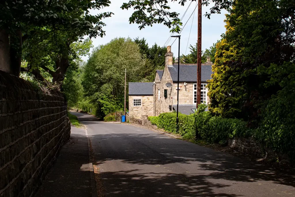
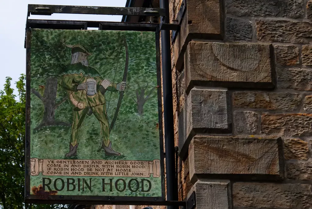
As Myers Grove Lane bears left, take the half-right turning onto Greaves Lane (signposted as a cul-de-sac) and walk along this lane with a meadow to your left and the houses of Wisewood visible over to your right. Stay on this lane as it climbs steadily, eventually emerging at the old Robin Hood Inn which is no longer used as a public house and is now apartments.
Look for the information board opposite the Robin Hood, before walking past the building and taking the widest path marked as a Public Byway, past The Glen. Head uphill on this wide track which eventually emerges onto a quiet tarmacked lane which continues to climb.
High Matlock & Acorn Hill
At the point where the lane turns left to have houses on either side, keep straight ahead along the Public Footpath and follow this with a wire fence between the path and the steep drop of Acorn Hill to your right.
As the fence turns 90 degrees right downhill, turn right following the path beside the fence, as it soon turns left again and crosses a stream waterfall. Ford the stream taking care over the slippery stones and continue beside the fence, joining another path where the fence ends.
(the stream crossing can be avoided by heading straight ahead instead of following the fence, this path follows on to meet the route at this point).
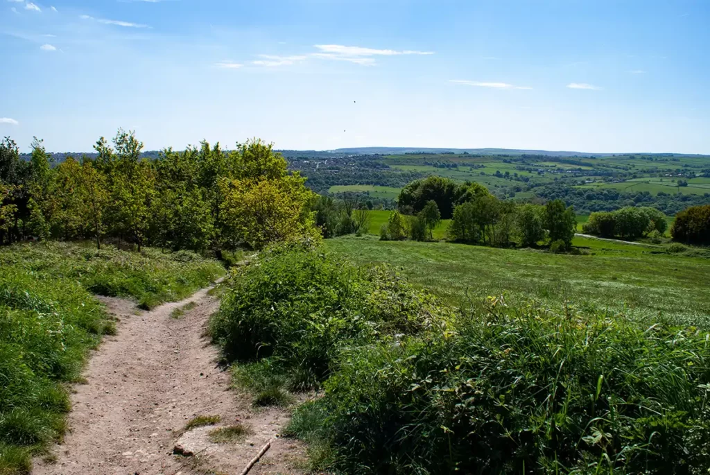
Continue west along the clear path with views across Loxley Valley through the trees to your right.
Pass through a wooden stile and continue along the top of the bank, now with a wooden fence to your right.
It is wise to keep dogs on leads here as where the wooden fence ends for a period, there is a gap in the fencing, trees and shrubs providing a natural border above knee height for humans, with a sheer drop.
After a stone post, you can pause and carefully view over the edge if you wish, taking care whilst doing so, before continuing along the level path which emerges at a road close to a bus stop.
Note a viewpoint and bench here with views across the valley if you wish to pause for a breather after your ascent.
Do not walk along the road, instead follow the footpath immediately adjacent on the right, with a central concrete post and follow this path as it curves gently left downhill, soon becoming roughly paved.
As the path descends, it leaves the trees, the views opening up across the valley. On reaching a gate, bear downhill between fences. Follow the partially paved path as it turns left, then right through a stile continuing downhill.
Pass through a second stone stile and continue descending on the clear path.

On reaching a short flight of 5 stone steps, descend these and then bear right down another flight of steps with steel pipe handrails and cross a stone bridge, pass behind a garden and emerge at a road at Rowell Bridge.
Beacon Wood
Turn left along the road to cross the bridge, taking care as the road narrows with no footway over the bridge. Immediately after crossing the bridge turn right onto a path into Beacon Wood. Take the right of the 2 paths, passing through a gap in a wooden fence and look for a stone in the wall on the left, indicating the height of the flood waters of the Great Sheffield Flood of 1864, where the Dale Dyke Dam in Bradfield bust, sending around 700 million gallons of water surging down this valley, sweeping away everything in its path, with damage or loss of over 600 houses and a death toll of at least 240 as the flood waters continued through the valley, to Hillsborough and through Sheffield.
After a short climb, the path levels out a little, above the River Loxley that runs below on your right. Follow this quiet path and enjoy the birdsong in these quiet woods. Path rough a stile and continue through the woods which in the springtime may be carpeted with bluebells, then emerge into a clearing.
Continue through the clearing following the clear path passing to the right of a wooden marker post, follow the path through the trees. Bear right where the path meets another coming on from your left and head downhill, again keeping right and downhill as you pass another path on your left.
Descend behind a row of houses and pass through an industrial estate of works buildings, crossing a red brick bridge and bearing right along a wide gravel vehicle track. Where the gravel track swings left, take the Public Footpath to the right, over a stone stile and gate. Pass the bowling green to your left and continue along the path which eventually leads back to the road at Rowell Bridge.
Down Loxley Valley
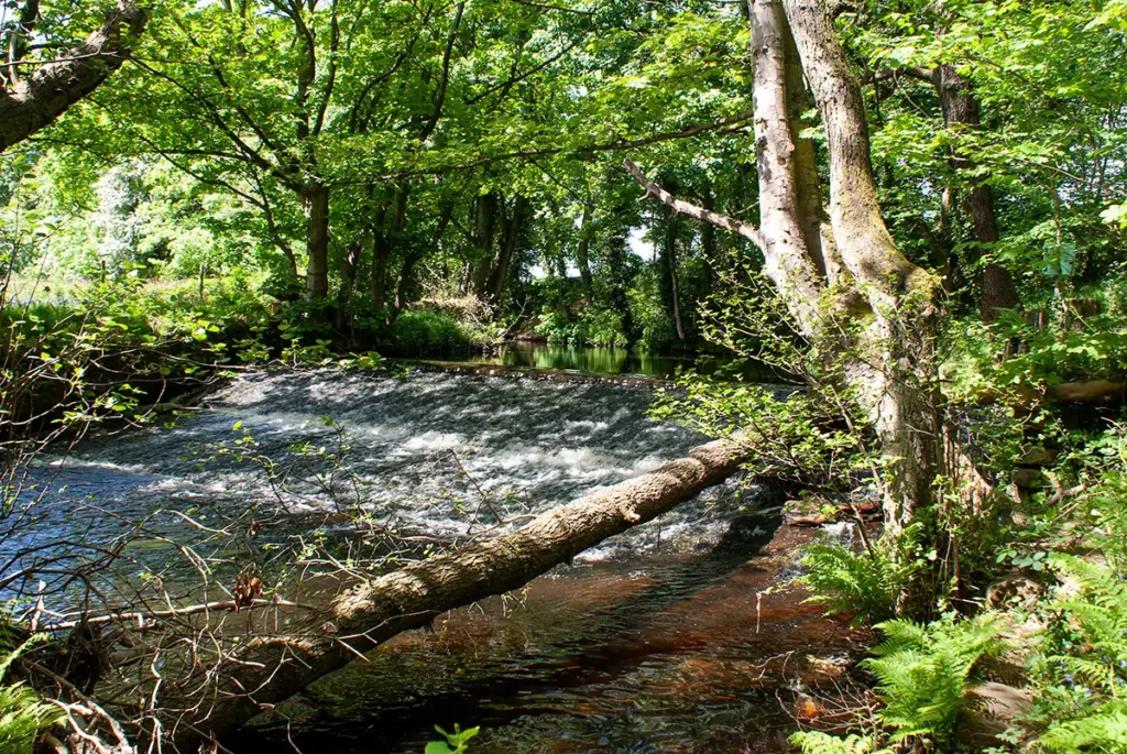
At the bridge, walk left along the road for a few yards, then cross over and take the footpath directly opposite Rowell Bridge Pumping Station. Walk along the right of the stone wall with fields to your left, and look for a narrow path forking off to the right and heading down to a weir with the remains of water mill workings.
Follow the narrow path along the riverbank then rejoin the main path beside a footbridge, and continue heading east along the river, passing a large pond on your left and keeping straight ahead.
After passing behind houses, the footpath turns left at a wall. Cross a stone bridge then turn right, taking the gravel vehicle track.
After a while, pass a wide double gate on your left then shortly after this arrive at a ladder stile with a metal Public Footpath sign pointing almost back the way you have just walked. Cross this ladder stile and double back over the meadow on the footpath. Follow this well-worn path gently up the meadow. The path then turns right and heads up the hill over two stiles beside Loxley Cemetery. Stay on this path as it turns right then left following the edge of the cemetery and up the hill to Loxley Road opposite the Admiral Rodney public house.
Wadsley Common
Cross Loxley Road and walk up Hanson Road to the left of the public house. That the first right onto Chase Road and then the second left onto France Road. Where France Road turns sharply right, go straight ahead up the Public Bridleway continuing steadily uphill.
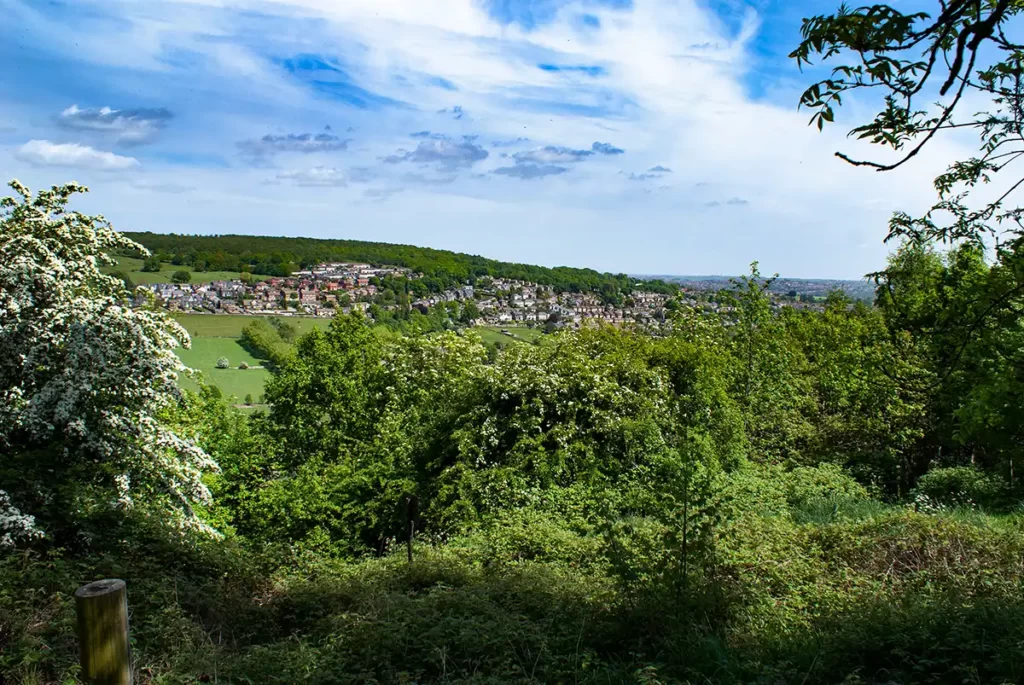
Follow the bridleway as it turns right at a wall then, as the bridleway heads into a wooded area follow as it bears half-left at a horse stile. On reaching a Bridleway T-Junction go left. Keep climbing along the main bridleway ignoring smaller paths off to the sides until you reach a quiet tarmac lane and viewpoint with views back over Loxley Valley.
Turn right along the lane enjoying the stunning views over the valley. Pass through a small car park, head through the gate and keep straight ahead on the main bridleway. At the next signposted junction stay right (Public Bridleway).
At the next footpath junction look to your right to see the trig point. To visit and “bag” this trig point go right, where you can also view rocks which show the closeness of the Sheffield outskirts to the Dark Peak.

Turn back and head to the last path junction and turn right, following the path which runs to the right of the stone wall. Follow this slightly rocky path through trees until the path briefly widens into 3 distinct paths. Here, take the rightmost path that begins to descend. Keep on this path downhill and keep this bearing, descending, passing to the right of buildings then, at a path crossroads go straight ahead over a horse stile and descend further.
Upon reaching a junction by a metal fence, bear right. dropping down to a road
Loxley & Wisewood
Turn right along the road into Loxley, noting the old stone post marking the border of Sheffield, then take the bridleway on the left directly opposite the bus stop, this bridleway continuing downhill with views of Sheffield suburbs.
Here, do not take the clearer route which runs behind the gardens of the houses, instead pass between the two groups of trees and then look left to see a path. Take this path on the left as it crosses a stream and skirts around the left of a pond.
On reaching the tarmac pavements, bear left, cross the road and descend the public footpath which runs adjacent to the end house, which drops down to Loxley Road.
Cross Loxley Road and head down Low Matlock Lane. Follow this lane as it becomes a track and then, at the wall corner on your right, take the Public Footpath on the left.
After a few metres along this footpath, take the path which heads off half-right down a flight of steps which leads to the ruins of Broadhead Wheel Mill which was heavily damaged in the flood of 1864.
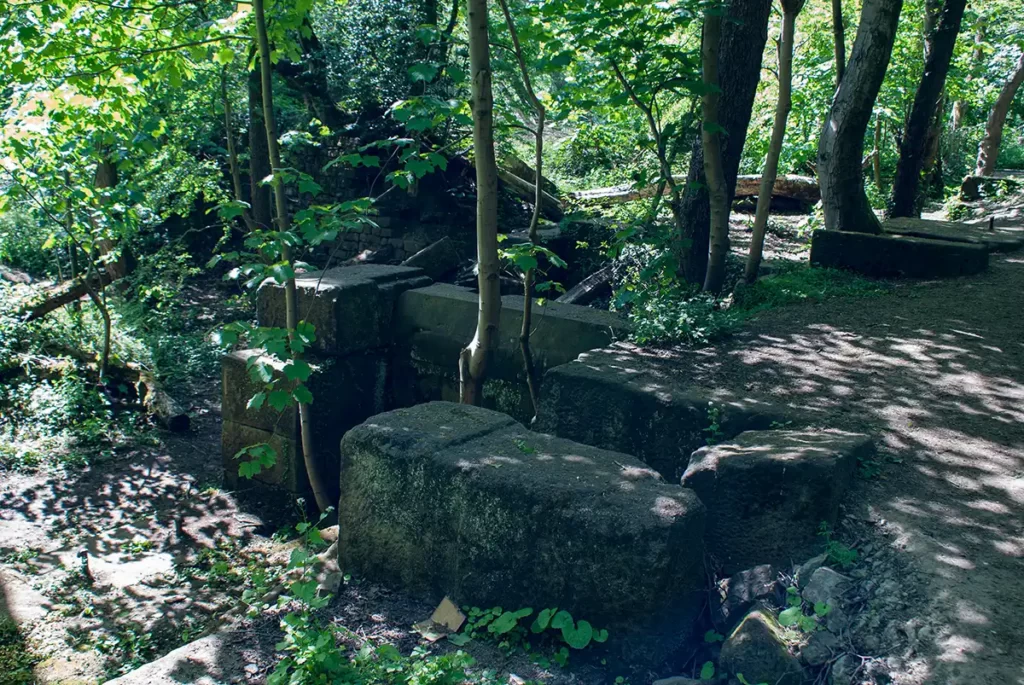
The site was purchased a few years after the flood and rebuilt as Loxley Steel Works also known locally as Denton’s Forge.
Some remains are still visible with parts of the retaining wall from the old mill dam evident. Cottages and the mill itself were all demolished prior to WW2 with no remains visible, the site being reclaimed by nature.
Continue on past the mill site along the main path then take the steps down to your right as you approach Wisewood weir.
At this point, you may hear the rhythmic turning of the Archimedes screw turbine at the hydroelectric plant.

Pass the weir and stay along the path beside the river, passing a mill pond and the residential homes at the site of the old Upper Wisewood Forge.
Continue along this path which rapidly becomes more urban, then joins a driveway heading up to Loxley Road. Join the road and walk to the main road junction. Bear right and head anticlockwise around (against) the one-way traffic route, carefully crossing Stannington Road and Rivelin Valley Road, to join Holme Lane and head back to the starting point of the Park & Ride.