A varied walk in the South-Eastern section of the North York Moors close to Scarborough, visiting the remains of a 14th-century castle before walking along a wooden walkway beside the river in Forge Valley, a haven for wild birds. The walk then takes you northeast through Raincliffe Woods to arrive at Throxenby Mere before climbing steeply to a bronze-age burial mound with views over Scarborough, the moors and the Yorkshire Wolds. From Seamer Beacon, walk steadily down Irton Moor returning to the small but busy villages of East and West Ayton.
Forge Valley & Seamer Beacon Walk Overview
Distance: 8.5 Miles (13.7km)
Total Ascent: 1207ft / 368m
Time: 4hr 15m
Map: Ordnance Survey Explorer OL207 (North York Moors – Eastern Area)
Get this route on the OS maps website & app
The time is loosely based on Naismith’s Rule and will vary depending on the walker.
Getting There
By Car:
Roadside parking on the westbound carriageway of Ayton Bridge between East and West Ayton on the A170 Scarborough – Pickering Road, just before the Ayton Methodist Church at YO13 9HH
Public Transport:
A bus stop serves Ayton Bridge from either direction. EYMS service 128 runs between Scarborough & Pickering, with York & County Coastliner service 843 travelling from Leeds to Scarborough
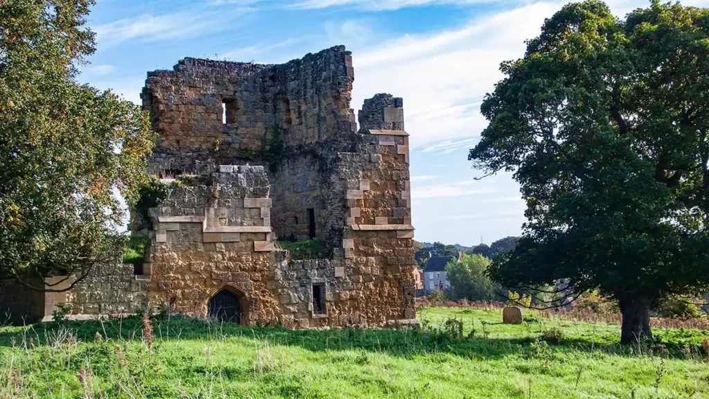
Ayton Castle & Forge Valley Boardwalk
From Derwent Bridge on the border of East and West Ayton, walk west towards the methodist church. Cross the road opposite the church and walk up Mill Lane. Follow Mill Lane as it bears left to a junction, then turn right up Yedmandale Road. Walk up Yedmandale Road to Castle Rise on your right. Turn right (signposted “Footpath to Forge Valley” and walk past the row of cottages on your right. After the cottages, keep straight ahead through the hand gate onto the Public Footpath. You can see the remains of Ayton Castle ahead in the field.
Follow the footpath, passing the castle on your left. The path drops gently towards trees and through a gate. As the path drops into the next field, bear left keeping to the left side of the field. Stay on the left of the field as the field narrows briefly where the Derwent snakes in to almost meet your path before it meanders off to the right. Stay on the path on the left beside a fence and brush until you reach the end of the field at another hand gate.
Pass through the gate onto a wooden boardwalk which runs left of the River Derwent. The wooden path does have strips of anti-slip coating but nevertheless can be slippery when wet or in the autumn when it may be well carpeted with fallen leaves.
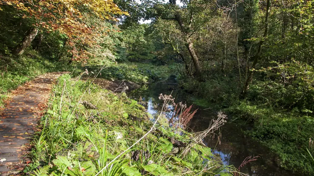
Follow this boardwalk for approximately a mile as it follows the course of the river. You may hear a variety of birdsong from the woods around you, a part of the Forge Valley Woods National Nature Reserve. After almost a mile, pass ‘Old Man’s Mouth’ car park/picnic site on your right (on the opposite bank of the river) and then shortly, a footbridge. Turn right to cross the footbridge and walk through the car park to the road.
Hazel Head Viewpoint to Throxenby Mere
Turn briefly left (north) along the road then right onto a Public Footpath at the brow of the hill. The footpath almost doubles back on your route for a short section as it climbs up through the trees into Raincliffe Woods. Step over a long-fallen tree and cross a wooden bridge. The path gets steeper as it climbs over another wooden bridge and up to meet another path. Bear left, the path levelling out as it winds generally north between bramble bushes and undergrowth for a section before becoming easier underfoot.
Keep straight ahead past a path coming in acutely from the right (signposted “Geology Trail”) then again straight on passing another unparked path with steps on your right. The main path then descends, swinging around to your right and down to Green Gate car park.
To visit Hazel Head viewpoint, exit the car park left onto the road down to the T-junction. Turn right at the junction and then turn left through a gate, into the picnic site with the viewpoint and information board in front of you. The board is filled with information on the geology of the area, the history of how the landscape was formed and the ammonites that can be found in the area.
Retrace your steps to Green Gate car park then head east into Raincliffe Woods along the partly surfaced track. This forest track climbs steadily as it meanders through the woods. Walk past two wooden marker posts numbered 21 and 20 then reach a picnic site in a clearing.
Approximately 1/2 mile after the clearing at a fork in the path, bear right along the “Moor to Sea” bridlepath. Emerge from the woods between two carved tree trunks into “The Meadow” and walk up the meadow. The path then heads back into the woods at the far end of the meadow. The path bears right then left as it continues its meandering course generally eastward.
At a signposted fork, bear right. This track climbs a little and then undulates, gradually bearing right. Bear right at a path junction and climb briefly but steeply to a path signpost. At the signpost, turn left downhill, keeping left until you reach a wooden path marker on your right. Bear right at the marker post following the clear path downhill. After a short steep section, the gradient eases slightly. Turn right here before the path ahead drops steeply again, and follow the path down to the mere below.
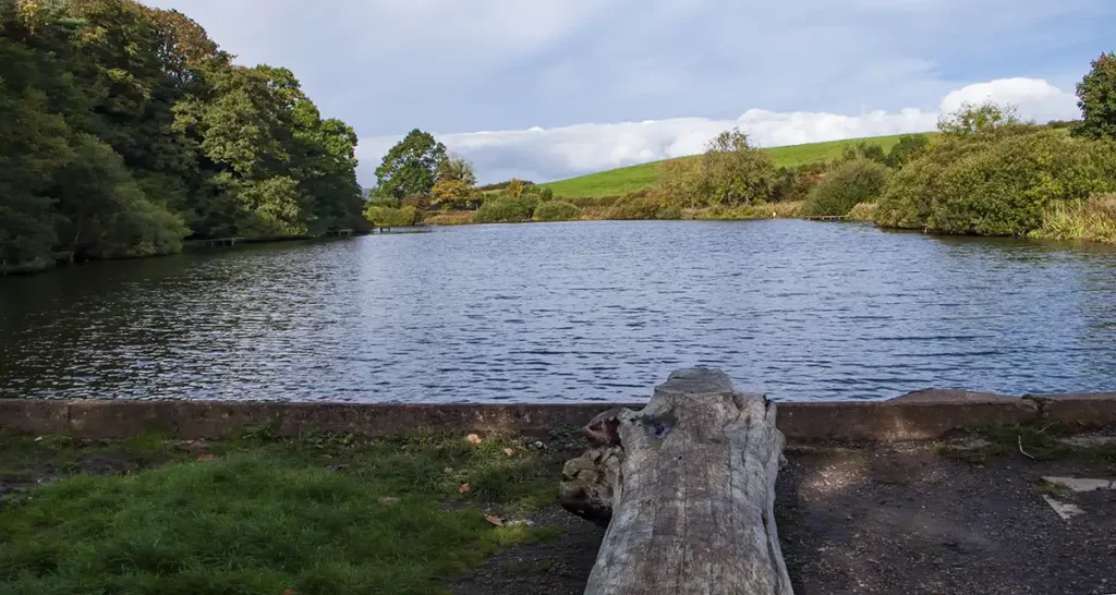
Throxenby Mere to Seamer Beacon
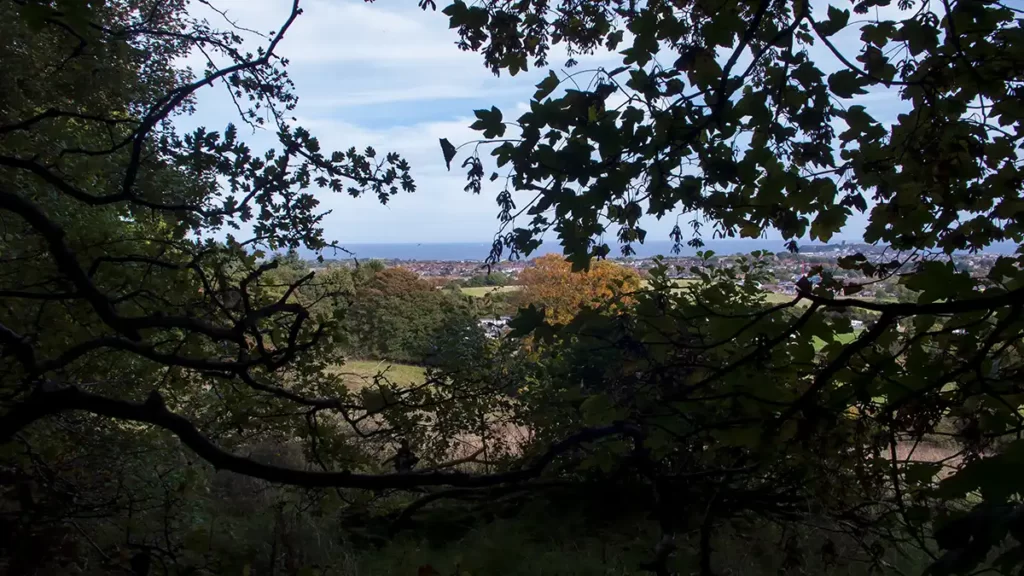
Turn right out of the Throxenby Mere car park then immediately right up the drive beside Lady Edith’s Holiday Park caravan site. Head up the drive until it turns left; at which point keep straight ahead. Walk up the roughly surfaced path uphill into the woods. Pass a stile and fence on your left, keeping straight ahead and ascending. After a short muddy section of the path, if you look left through the trees you are rewarded with good views over Scarborough and the East Coast.
At the next section of the climb, you have two path options both heading in the same direction uphill. The left-hand, higher path is the drier option before the two paths converge again. Continue uphill until you leave the woods at the GCHQ radio masts.
Go straight ahead along the track with the shorter mast on your left. At the end of the fence on your left, turn left then, just before a gate ahead, go right on a narrow path into trees. This path then bears left, passing behind the radio transmitter. Keep straight ahead through two hand gates (at the time of writing, October 2022, the second gate had collapsed). Reach a third gate then bear right into a field. The tree-topped mounds of Seamer Beacon can be seen ahead.
Walk along the left of the field almost to the far corner then turn right on a trod heading across the field near the side. Turn right again and walk along the edge of the field until a faint path heads left up onto the tumulus.
From the top of Seamer Beacon, you gain a 360-degree view, albeit through trees, with Scarborough and the east coast down as far as Filey Brigg on a clear day. In the other directions, views over the eastern North York Moors and south to the Yorkshire Wolds.
Seamer Beacon to Ayton
After taking in the views, retrace your steps around the field and through the path back to the radio masts. After the transmitter, turn left (southwest) along the vehicle track with fields on either side. Keep straight ahead on this track down Hagworm Hill, passing a barn and house on your left.
At the crossroads beside East Ayton Moor Farm turn right along the Public Bridleway. Follow the wide farm track with the woods of Whin Covert on your left.
As you reach the end of Whin Covert turn left down the left-hand side of the field. With the covert to your left, you can see the hills of Staxton and the Yorkshire Wolds ahead. Follow the path to the bottom of the field.
At the bottom corner of the field, the path bears slightly left to continue downhill between field hedgerows. On reaching the foot of the hill, the path leaves the hedgerows. Passing gates on either side follow the path which bears right becoming a farm vehicle track. Ascend the track to meet a road.
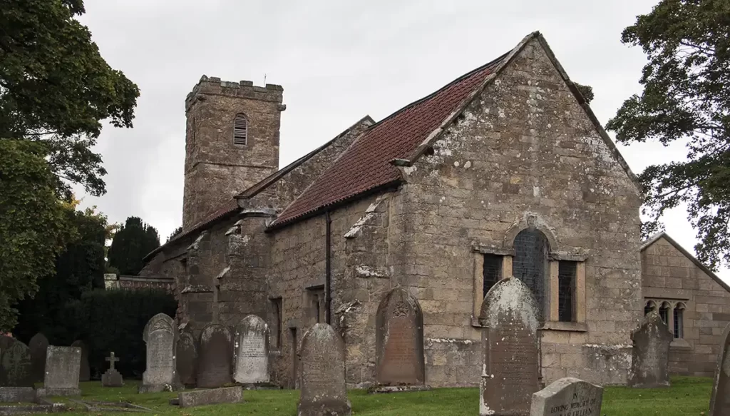
Bear right along the road and follow it to the very end into East Ayton, passing the school entrance on your right. Turn right at the junction, and walk alongside the main road, passing the church on your right. The Church of St John the Baptist in East Ayton dates back to the early 12th Century.
Cross the road at the crossing after the church, then continue along the main A170 road. Pass the filling station and mini-supermarket on your left and continue to Ayton Bridge and the start.