Beginning from Moscar Cross, this Dale Dike walk heads over the low moorland of Ughill before dropping to the reservoir. An easy-to-follow path heads anti-clockwise around the reservoir. Our route then climbs back up the moor by Lee Bank to Sugworth Edge and the curious tower of Boot’s Folly. A path behind Sugworth Hall and Lodge Moor takes us back to the start.
Dale Dike Walk from Moscar Cross Overview
Distance: 7.5 Miles (12km)
Total Ascent: 1195ft / 364m
Time: 3hr 45m
Map: Ordnance Survey OL1 (Dark Peak)
Get this route on the OS maps website & app
The time is loosely based on Naismith’s Rule and will vary depending on the walker.
Getting There
By Car:
Park near the gas pipes close to the junction of Sugworth Road and Mortimer Road, off the A57 between Sheffield and Ladybower. Nearby postcode: Moscar Cross Farm S6 6GL
Public Transport:
Bus Service 257 Sheffield-Hope stops at Moscar Grange on the A57. Walk east from the bus stop then left up the drive to Moscar Cross Farm then join the route after passing beside the farm, turning right to walk behind the farm.
Moscar Cross over Ughill Moor
Park near the gas pipes on Sugworth Road. Head east over the stile beside the gate, up the track marked as a Public Byway. Follow the byway track beside the wall, up through 2 gates, bearing right after the second gate. Still following the wall, now heading downhill, keep to the main track which then turns left to pass Moscar Cross Farm. (Join the walk here if travelling by bus)
Continue past the farm, walk under overhead power lines and keep straight ahead past a stile and gate on your left. Reach a gate ahead and pass through it, after which the track remains clear but is evidently less used by farm machinery and vehicles at this point. The track climbs gently then, at a fork, bear left up a track (Stake Hill Road) climbing onto Ughill Moor.
Following the track with a drystone wall to your left, pass through a gate beside a cattle grid and continue along the track. The stone wall to your left is now broken in places. The Stake Hill Road track levels off at the top of the moor and then begins to descend gently – the wall to the left is now obviously maintained. Pass through a gate just beyond an old stone post and continue down the track. The track then descends to a minor road.
Oaks Piece Plantation to Dale Dike Reservoir
Turn right along the minor road for around 100m then turn left over a wooden stile in a gap in the stone wall onto a Public Footpath. Head along the footpath with the plantation to your right, climbing gently uphill. After the brow of the hill, the path descends to another road.

Cross the road and climb over the ladder stile opposite. Walk along the right-hand side of the field with a fence and then a wall on your right.
Towards the far end of the field, keep right. The path takes on a miniature dark peak character as it drops down beside gritstone to a third road. Cross the road and continue downhill. Take care on the descent which is rutted with tree roots as it drops steeply. Cross 2 plank bridges, then reach a path junction shortly after the second bridge.
Turn right over a stone step stile into Wragg House Plantation. Walk along the forest-like path between the trees until another path junction. Turn left downhill, soon with a stone wall on either side of the path. Keep heading down towards the reservoir, over a stone stile (take care – a steep drop at the opposite side!) and turn right along the path.
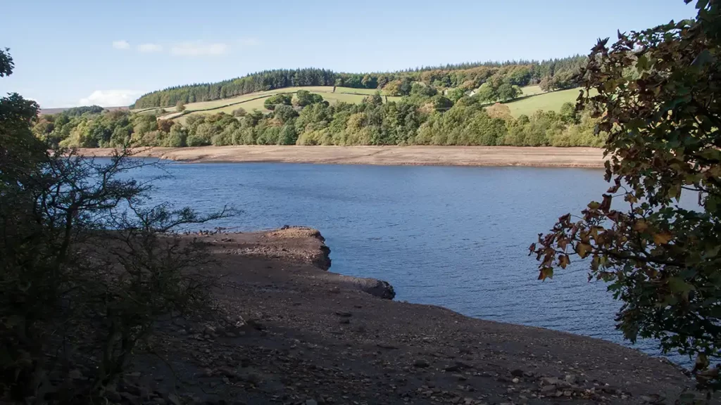
Around Dale Dike Reservoir
Walk along the path with the reservoir to your left. Pass the ornate iron bridge on your left and continue roughly northeast along the waymarked path through the trees.
At a fork, the path bears left down a flight of steps with a wooden handrail. At the bottom of the steps bear half-right towards another handrail visible ahead. Descend the next flight of steps to the pumped outlet. From the outlet, head right along the obvious path from the bottom of the steps. Shortly reach a footbridge on your left. Cross the footbridge and follow the track left as it climbs upwards. The track weaves up to a right-hand horseshoe bend. Stay on the track around the right-hand bend to reach a path junction.
Turn sharp left at the path junction. On reaching a metal gate, take the path leading right of the gate, through two wooden hand gates to follow the path along the north of the reservoir.
The path heads through trees with the reservoir to your left. Follow this pleasant, sun-dappled path with fields and farmland rising to your right. You pass a number of small beach-like areas beside the reservoir (depending on the water level and season). The path rises a little as you reach the southwestern end of the reservoir, passing a wooden guardrail on the left.

The path drops down to a footbridge. Cross the first footbridge and immediately turn left, passing below overhead power lines. At a fork in the path, bear right, away from the stream on the left, climbing to a stile over a wall.
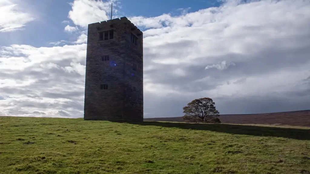
Dale Dike to Sugworth Tower (Boot’s Folly)
Cross the stile then turn left alongside the wall to your left. Continue heading in this general direction – the path veers slightly right, away from the wall then shortly the wall climbs back up to the path from the left.
Upon reaching a wooden gate and stile ahead, do not go over the stile. Instead, turn sharp right on a path which almost doubles back to steadily climb the same field. The path heads through a patch of bracken, emerging to pass through a gap in a stone wall, beneath a tree.
After crossing a shallow watercourse (little more than a trickle) with a tower of a dam visible ahead, the path bears left to climb up rougher ground. The path climbs to a wall and turns left alongside the wall. Continue to climb, roughly following the line of the wall on your right. Strines Reservoir can now be seen clearly below to your right. The tower of Boots’ Folly comes into view ahead as you climb.

When you are almost level with the dam wall below to your right, the path bears half left away from the wall, continuing to climb and then bears right onto a clear track where a fainter track comes in from the left. The path is now more level as it heads alongside Strines Reservoir below. Pass a short rocky section then climb again, much more sedately now, bearing slightly left heading towards the tower. Pass immediately left of a small fenced-off enclosure then stay along the path, still heading in the direction of the tower.
A stone-paved section of the path heads over a reedy, boggy area of ground. Follow the path between a small stretch of bracken into the field containing Sugworth Tower, or Boot’s Folly.
Sugworth Hall back to Moscar Cross
Walk along the left of the field, passing the tower over to your right, to reach the wall beside Sugworth Hall. Walk through the gate and follow the clearly marked and fenced public footpath. The footpath passes behind the hall and emerges, past the hall, onto the driveway. Walk up the driveway, leaving the Sugworth Hall grounds, to the road.
After exiting the drive, turn right and walk along the minor road. The road climbs a little then levels off. After it levels, keep an eye out for a stile on your left over a stone wall, just before a small line of trees. Turn left, crossing over the stile and head up the field, following the line of the wall to your right.
Stay on this path as it climbs Lodge Moor, crossing 2 stiles and continuing with a stone wall to the right, descending to a gate with a stone stile to the right. Cross the stile and turn right onto the track. The track, which you may recognise from the outbound leg of your walk, heads back to Moscar Cross Farm.
Retrace your earlier steps, passing the farm then turning right to walk up to the gate then down the byway to return to the start.