A rewarding Longstone Edge walk, across the countryside from the village of Great Longstone, climbing to Longstone Edge with vistas over Eyam, then the tumulus on Longstone Moor with a 360-degree view above Bakewell. Easy-to-follow paths, some short but strenuous steep sections, numerous stiles
Longstone Edge Walk from Longstone Moor Overview
Distance: 6.45 Miles (10.4km)
Total Ascent: 1027ft / 313m
Time: 3hr 45m
Map: Ordnance Survey OL24 (White Peak)
Get this route on the OS maps website & app
This route on Komoot
The time is loosely based on Naismith’s Rule and will vary depending on the walker.
Getting There
By Car:
Park considerately in the village of Great Longstone west of Hassop. Parking on the road opposite The Crispin public house avoids parking outside residents’ homes and provides a convenient starting point. DE45 1TZ.
Public Transport:
A bus stop at the starting point of The Crispin pub is served by Hulleys of Baslow service 173 (Bakewell-Castleton) Connection via Train can be made from the Hope railway station and catching the 173 service towards Bakewell
Great Longstone to Longstone Edge
From The Crispin, walk along the road heading downhill. After the village war memorial on your right, turn left up a drive, signposted “Footpath to Church”. Take the hand gate on your right to the church then bear half-left through the churchyard. Pass the church on your left and make your way to the left corner of the churchyard, where you exit onto a road at a bend.

Keep straight ahead along the road then, after passing Church Croft (the last building on your left) bear half-left diagonally through a small field to a squeeze stile. Pass through the stile and bear right on a footpath between two stone walls. Continua ahead through another squeeze stile then through a gate and up the next field.
Leave the field by another stone squeeze stile, cross a narrow concrete farm track and continue ahead over the field. Keep heading in the same direction over 2 stone stiles crossing a footpath (Hardrake Lane) and up the next field, bearing slightly left after the initial slope eases, heading to another squeeze stile beside an old tree.
Cross the next field heading towards 2 metal gates approximately halfway along the opposite side of the field. Cross the stile between the two gates and keep going straight ahead with a drystone wall to your right. Pass over a broken stone wall just right of an old stone farm building. Continue to the concrete farm track then turn left to climb the track.
Follow the track through a gate, then, as the track turns sharply left, go through a hand gate on the right then turn immediately right, aiming towards the wall corner at the opposite side of the field (left of a tall gatepost). Pass left of the wall corner then head to the gap in the stone wall ahead under trees. Pass through another squeeze stile and keep straight ahead, remaining towards the bottom of the field.
Head through a gap where a gate no longer stands and continue along the bottom edge of the next field, passing an old stone trough on your right, then entering the next field. Keep right, alongside a low mossy stone wall into the next field, and continue along the bottom edge to reach a metal gate with a steep stone stile to the left. Climb the stile and cross the gravel path, keeping straight ahead over another stile.
The path bears slightly right across the field, heading towards the bottom right-hand corner. Climb the stile over the stone wall at the very corner of the field and onto a minor road. Turn left to walk up the road, towards a right-hand bend and a cattle grid.
Walk Along Longstone Edge
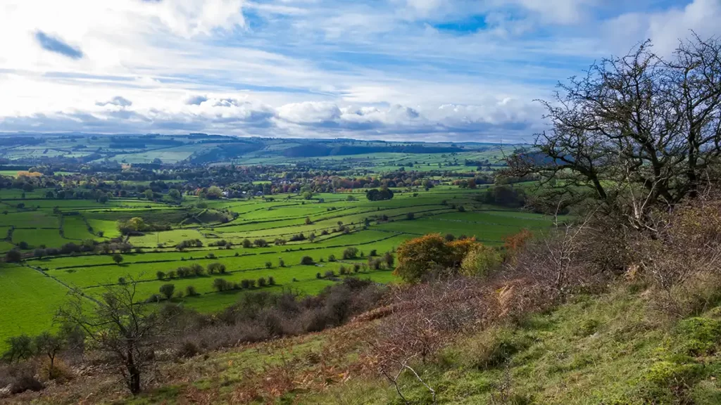
Just before the right-hand bend and cattle grid, turn left and climb over the stile. Walk up the clear gravel-surfaced path with views over Great Longstone and Bakewell opening up to your left.
When the path briefly widens into a circular area resembling a vehicle turning area, continue straight ahead. The path ahead climbs briefly and fairly steeply to meet another gravel path. Cross the path and continue ahead over the stile just to your right, to keep climbing up the grassy path.
Follow the path as it heads into brush and then with a gully below to your right, reaches a stone wall ahead. Turn left at the wall then right through the hand gate. Keep straight ahead after the gate, climbing steadily to join with a gravel path along Longstone Edge. Continue ahead, joining the gravel path. You can now see views over the villages of Little and Great Longstone, the town of Bakewell, and all their surrounding Peak District countryside.
Follow the main track which runs just below the trees which line the top of Longstone Edge at this point until a path junction. At the junction, the gravel path peels off to the right uphill – instead head half left gently downhill to pass beneath overhead power lines. After the power lines cross a stile beside a gate and continue straight ahead, climbing up the main path along Longstone Edge.
The track climbs once again, bearing slightly right before leveling off and then descending a little. Stay on this main, obvious path, ignoring other narrower tracks that head up half right to the road above. Eventually, the path narrows and heads into brush. Continue through the brush, passing through a hand gate and then emerging onto a road before a cattle grid.
Watersaw Rake & Longstone Moor
Bear left along the road, crossing the cattle grid. Follow the road as it bears left downhill, passing a gate on your right. Where the road turns left a second time, turn sharply right through a hand gate and up the public footpath.
The footpath crosses a track – keep straight ahead climbing the steps, signposted “Footpath to Longstone Moor”. Continue up the path, now climbing very steeply. When the path turns left with two other paths heading straight ahead and half right, follow the path left, continuing to steeply climb to reach a gate.
Head through the gate, taking note of the warnings regarding open mine cast workings. There may be hidden disused shafts so it pays to keep to the pathways and to keep dogs on a lead.
Continue along the path heading roughly north, still climbing. It’s worth pausing for views behind you at this point – a good excuse to catch your breath as you continue up onto Longstone Moor. As the path eventually levels out, keep straight ahead at a path junction and continue past fenced-off mineshafts on your left and another path junction with a direction sign.
Turn left along the track, signposted “Castlegate Lane” and follow the wide grassy track. As you reach the end of the enclosure around the open mineshafts keep straight ahead. Follow this grassy track to pass between two groups of trees then bear to the right towards a cairn.
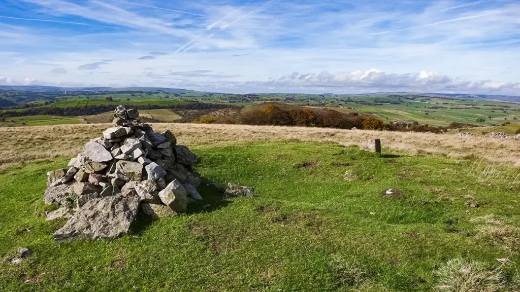
From the cairn on the tumulus, you are gifted with a full 360-degree view of the surrounding area for miles on a clear day. After drinking in the views, continue along the grassy track as it heads downhill. Where the track forks, take the left fork down to a gate.
Longstone Edge to Little Longstone
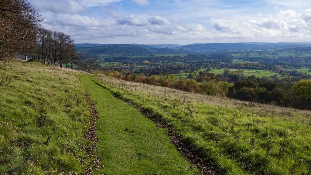
Pass through the gate and descend to another path junction and signpost, just before an enclosured dew pond. Turn left at the path junction, signposted “Longstone Edge” & walk along the grassy track which runs parallel to the road below you on your right. Pass a gate on your left then, after the gate, cross the stile on the left over the stone wall.
Turn right after the stile and follow the grassy track as it curves left beside the trees, with views of Great Longstone ahead of you. The clear path heads down the hill to reach a gate and stile. Across the stile, the path turns right to immediately reach a track. Turn left down the track (with a “No Motor Vehicles” sign) and stay on this track, descending for roughly 3/4 mile until you reach Dale Farm on your left.
Pass farm buildings then, when the track turns sharply left, turn right through a hand gate into a field with a tall old iron pump. Keep along the left of the field to another gate, then continue again keeping to the left. Keep straight ahead as you pass a farmhouse on your left. Just after passing a ruined building on your right, turn left through a hand gate and descend to a road.
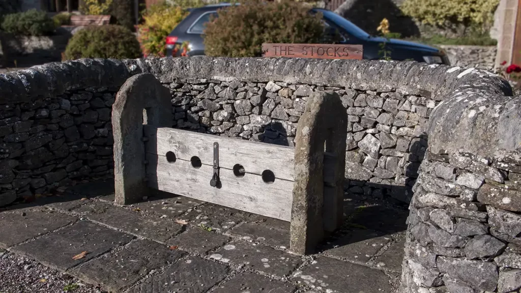
Turn right along the road towards Little Longstone. Walk along the roadside as there is no footpath at this point. Pass the old stocks on your right.
Little Longstone to Great Longstone
Just before reaching the right-hand bend, and just before a roadside footpath, there are two public footpaths heading off to the left. Take the first path, turning sharply left to head diagonally up the field. (Not the path signed Ashford and Monsal Trail).
Pass through two hand gates then head half right across the next field. Head through a stone stile, crossing a track and through a hand gate & squeeze stile into a tiny field. The path is clearly marked and obvious here. Pass through another hand gate then keep straight ahead, walking to the right of a fence.
At the far side of the field pass through another hand gate/squeeze stile combination then keep left through another small field; exiting by the gap in the wall in the far left corner, onto the road at Great Longstone.
Cross the road and go straight ahead on a tarmac footpath. Continue past the school and a small green on your left. Turn left just before the recreation ground and walk through a small car park. Leave the car park through the wall gap on the far right corner. Follow the path between stone houses and buildings, which leads out to the main road beside the White Lion public house.
Turn left beside the White Lion and walk back up the road to The Crispin and the start, to conclude your Longstone Edge walk.